Wells City Archives - Mapping the Border
Wells Town Hall, Market Place, Wells, Somerset, BA5 2RB
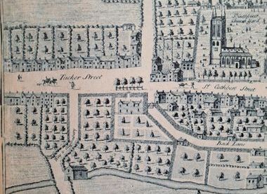
This pop up display will show how the city boundary is described in some of the earliest items in our collection. Thanks to Lambeth Palace Library we can also see a photographic copy of what is believed to be the earliest known map of the City from 1601. This can be compared to later maps and plans, such as William Simes plan of the city in 1735, and a Victorian Sewerage survey in 1860. Finally, see how the city boundary is described even earlier, before the first known map of the city, in one of the earliest charters in the Wells City Archives collection.
Wells Town Hall, Market Place, Wells, Somerset, BA5 2RB